Rio sobre Rochas

CURADORIA

Marcelo Motta de Freitas

REVISÃO

Davi Aroeira

FOTOGRAFIA

Renato Oliveira

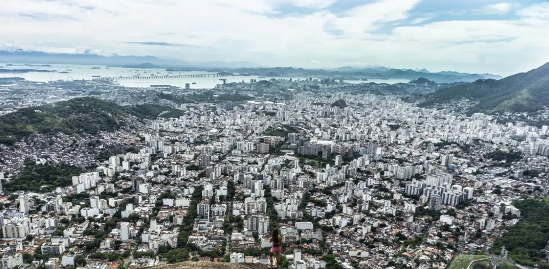
The production of the space we inhabit is the result of various processes accumulated over time in our materiality and social relations. Space is composed of the indissociable set between the occupied area (formed by reliefs, ecosystems, atmospheric dynamics) and the processes of occupation (relative to relations of power, culture, politics, social, and economic): an amalgam that registers, records, and graphs on the ground its unique and exclusive mark, which we commonly call landscape or, more deeply, geography – the graphics on the earth. This landscape is made of visible things and, also, of immaterialities that result from social relations and involve power, economic value, political and cultural interests. Geodiversity, among many definitions, can be understood as the diversity of geological and geomorphological features and processes that interact with culture, modeling the landscape. Rio de Janeiro does not escape this process, expressing very well in its geography the interweaving of buildings over rocky massifs, coastal lowlands, and the different ways of living in such distinct spaces. Each valley carved by a river or each lowland, with beaches and restingas, nestles and accommodates parts of our city and influences our lives. The rocky formations and their dynamics interact intensely with urban daily life, whether with the waterfalls that cool their visitors or the landslides and floods that afflict us in hot and rainy summers. It is not an easy task to inhabit Rio de Janeiro, a city where the relief is not just a scenery — it is the protagonist of the life that pulses between mountains, valleys, beaches, and lowlands. Since its foundation, the city has been configuring itself over this rugged terrain and the influence of these physical dimensions are present, designing the stage of events and shaping its own construction. It is in this unique relief that we inscribe our presence, diverting rivers, filling in marshes, beaches, and mangroves, climbing to the peaks and descending into the subsoil. We were and are forceful in the construction of our own living space. The geological history of Rio de Janeiro dates back to very ancient tectonic movements in continental collisions that forged, in high temperature and pressure, our rocks. Later, the separation of the continents and the opening of the Atlantic Ocean completely altered the relief and raised our sugar loaves, hunched hills, peaks, and serras. Tropical rains, storms, and tempests sought to lash and destroy these formations over the millions of years of evolution of this landscape. Valleys were carved, sediments distributed in low areas, rivers, marshes, and bays formed. Forests and associated ecosystems occupied their habitats with exuberant flora and abundant fauna. Humans recorded their first traces in the Rio de Janeiro and Guanabara region around 8,000 years ago and are associated with the global warming that the planet experienced with the end of the last glaciation. The tropicalization of these environments attracted human hordes who arrived through the Amazon and occupied the hinterland of Guanabara given its abundance of resources: mangroves, marshes, fish, crustaceans, fresh water from various rivers that reached the bay. After these prehistoric peoples came the tupinambás, temiminós, and other indigenous nations who occupied our territory. But this historical account is already in the gallery

Rio before Rio

and here we will deal with the spatial dimension of the facts, thinking about the geography of these processes.
Explore as salas

Riscos e desastres

A face hidden beneath the beautiful plumage of the Rio de Janeiro landscape with its forested mountains and coastal lowlands exposes itself in disasters in a complex and cruel way. Behind the city's beauty, there exists a production of geographical space marked by constant risks, especially from landslides and floods. With population growth and the lack of urban planning, especially due to the almost non-existent housing policy over the last five decades, the risk has intensified with heavy rains and urbanism ordered by the logic of the real estate market. The relationship with the city's urban site becomes dramatic when disasters destroy lives, goods, and parts of the city, revealing, above all, the fragility of the most vulnerable areas. In the last half of the 20th century and in more recent decades, the slopes and the morro areas of the city have been the stage for recurring tragedies. Morro do Borel, in Tijuca, the neighborhoods of Cosme Velho and Santa Tereza, and Morro do Vidigal, in Zona Sul, are just some examples of locations that, year after year, become victims of landslides. The housing crisis in the city and the historical slowness of responses to deal with geological risk have transformed many spaces into extremely vulnerable areas. Our morros, densely populated, and the floodable lowlands, have seen their communities buried by mud during periods of rain, with tragedies occurring in sequence, since 11967, 1988, 1996, 2003, 2010, 2018, 2019, and the last in 2023. Sliding is something natural for the Carioca mountains under the tropical climate; what is not natural is having residents underneath. Risk is a social construction, a product of the absence of housing policies in the city. A city that does not prioritize inhabiting, living well, but rather obeys the logic of the real estate market, which utilizes surplus value, differential rent, and the exchange value of properties to grow, or growth to profit. Living well in Rio de Janeiro is not a right of the population; it is a privilege of the few. Similarly, also provoked by "ordered" growth, another type of risk: floods, devastate the Carioca populations under heavy rains in the lowland areas. While the slopes collapse, the low-lying areas of the city become a true scene of chaos when rains fall torrentially. The old areas of marshes and mangroves filled in over the centuries, such as the classic example of Praça da Bandeira, are the regions most susceptible to flooding. The neighborhoods located there become, after any stronger rain, true revived marshes, areas that, historically, face drainage problems and end up flooded under the strong normal tropical storms. These floods do not only paralyze the city, but affect the lives of thousands of residents who see their streets transformed into lakes and torrents. In Zona Sul, the fill of Jockey Clube over the marshy areas at the foot of Serra da Carioca in the neighborhoods of Jardim Botânico and Gávea remains a barrier to the waters coming down from the massif and guarantees the flooding of the road network under heavy rains. The excess of waterproofing, the absence of infiltration areas or water rest areas, induce the excessive accumulation of rainwater, causing low-lying areas to become submerged. For a coastal city, this is truly a paradox. The North and West Zones, where the lowlands are wider and the city expands, guarantee seasonal floods for their urban settlements on full soils, called hydromorphic, which, as the name itself says, were formed under high water tables. What is not asked is how they built subdivisions and extensive housing areas in these environmental conditions? Marshes always flood, therefore, paving them and occupying them is a clear construction of risk. But the rentier logic of urban space does not correspond to the logic of reading the landscape and its functionality, which should underpin planning. In parallel, some municipal attempts (depending on the administration) have prepared the city to deal with these issues, advancing in drainage works, alert systems, and slope containment. However, acting on the consequences helps, but does not resolve. Actions such as the restoration of riparian forests, river desilting, and containment works in various risk areas are some of the strategies adopted. Nevertheless, the key to solving these issues necessarily passes through preventive policies that bring quality of life to the citizen, seeking urban planning and, principally, housing policy. The occupation based on the city as a commodity continues to be a problem for the Carioca.

enter

Explore as salas

Quer saber mais sobre a história do Rio?