Rio sobre Rochas

CURADORIA

Marcelo Motta de Freitas

REVISÃO

Davi Aroeira

FOTOGRAFIA

Renato Oliveira

The production of the space we inhabit is the result of various processes accumulated over time in our materiality and social relations. Space is composed of the indissociable set between the occupied area (formed by reliefs, ecosystems, atmospheric dynamics) and the processes of occupation (relative to relations of power, culture, politics, social, and economic): an amalgam that registers, records, and graphs on the ground its unique and exclusive mark, which we commonly call landscape or, more deeply, geography – the graphics on the earth. This landscape is made of visible things and, also, of immaterialities that result from social relations and involve power, economic value, political and cultural interests. Geodiversity, among many definitions, can be understood as the diversity of geological and geomorphological features and processes that interact with culture, modeling the landscape. Rio de Janeiro does not escape this process, expressing very well in its geography the interweaving of buildings over rocky massifs, coastal lowlands, and the different ways of living in such distinct spaces. Each valley carved by a river or each lowland, with beaches and restingas, nestles and accommodates parts of our city and influences our lives. The rocky formations and their dynamics interact intensely with urban daily life, whether with the waterfalls that cool their visitors or the landslides and floods that afflict us in hot and rainy summers. It is not an easy task to inhabit Rio de Janeiro, a city where the relief is not just a scenery — it is the protagonist of the life that pulses between mountains, valleys, beaches, and lowlands. Since its foundation, the city has been configuring itself over this rugged terrain and the influence of these physical dimensions are present, designing the stage of events and shaping its own construction. It is in this unique relief that we inscribe our presence, diverting rivers, filling in marshes, beaches, and mangroves, climbing to the peaks and descending into the subsoil. We were and are forceful in the construction of our own living space. The geological history of Rio de Janeiro dates back to very ancient tectonic movements in continental collisions that forged, in high temperature and pressure, our rocks. Later, the separation of the continents and the opening of the Atlantic Ocean completely altered the relief and raised our sugar loaves, hunched hills, peaks, and serras. Tropical rains, storms, and tempests sought to lash and destroy these formations over the millions of years of evolution of this landscape. Valleys were carved, sediments distributed in low areas, rivers, marshes, and bays formed. Forests and associated ecosystems occupied their habitats with exuberant flora and abundant fauna. Humans recorded their first traces in the Rio de Janeiro and Guanabara region around 8,000 years ago and are associated with the global warming that the planet experienced with the end of the last glaciation. The tropicalization of these environments attracted human hordes who arrived through the Amazon and occupied the hinterland of Guanabara given its abundance of resources: mangroves, marshes, fish, crustaceans, fresh water from various rivers that reached the bay. After these prehistoric peoples came the tupinambás, temiminós, and other indigenous nations who occupied our territory. But this historical account is already in the gallery

Rio before Rio

and here we will deal with the spatial dimension of the facts, thinking about the geography of these processes.
Explore as salas

Maciços e serras associadas

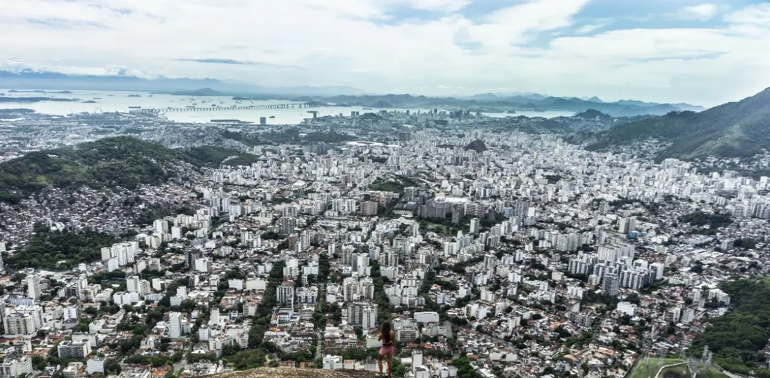
The geography of the municipality of Rio de Janeiro is, in itself, an exercise in deep reading between the matter of the earth and the processes inscribed within it. The city unfolds between the relief structured over ancient rocks and the more recent sedimentary plains, composing a landscape that amalgamates with historical and social processes. Three large rocky massifs — Tijuca, Pedra Branca, and Gericinó-Mendanha — sustain, as geological structures, the spatial narrative of the city. They are rocky bodies that resist time and, at the same time, mold, limit, and interact with the inhabited space, the flow of waters, and human paths. The Maciço da Tijuca, embedded in the heart of the city, was the first to be perceived and incorporated into the dynamics of the city's construction. The very foundation of the city occurs on its most extreme peninsula, to the East, where the Pão de Açúcar is situated, a feature symbolic of the city. Since the beginning of colonization, it is this massif that has named the spatial references of the city. The portion south of the Maciço da Tijuca was named Zona Sul, to the north, Zona Norte, and to the west of it, the Zona Oeste. Culturally, the division of these zones does not follow a geometric, nor a geodetic, division. It is in this same massif that iconic features rise, appropriated as Carioca symbols, such as Corcovado, Dois Irmãos, and the Pedra da Gávea, which have already been read as signs, divine portals, and city landmarks. With its rugged relief and covered by the Atlantic Forest, it operates as a divider and regulator: it separates zones, modulates winds, distributes rains, and imposes its own limits on urban expansion. The Parque Nacional da Tijuca — which covers much of it — is a witness to this complex exchange between the destruction and regeneration of landscapes. In the western portion of the municipality, the Maciço da Pedra Branca imposes itself in extent and altitude. Its culminating point exceeds one thousand meters, being the highest in the city. It is a forested massif, where the largest urban forest is located, although pressured by the city's edges that advance toward it. There, the Parque Estadual da Pedra Branca preserves springs, forests, and slopes, functioning as a source, reservoir, and memory. As for the Maciço de Gericinó-Mendanha, bordering the northern limit of the municipality, it participates equally in the morphological fabric of the city, separating it from the municipalities of the fluminense lowland. It accommodates, at its foot, the neighborhoods of Bangu, Santíssimo, and Campo Grande, and the peri-urban condition of the city's expansion over remnants of the municipality's last agricultural areas. It is a territory in tension — between what is preserved and what is lost — where its internal mountains, which accommodate an ancient volcanic chamber, witness the rapid transformation of the surroundings. Scattered among these large rocky volumes, various smaller mountains connote small folds of the terrain. Some isolated, others chained, they help compose the city's fragmented relief, marked by ruptures and fits between highs and lows, which separate neighborhoods from the plain areas. There they are, Inhoaíba, Paciência, Capoeira Grande from the western portion, up to the Serrinha and the Serra da Misericórdia toward the east. Surrounding all these elevations, the coastal plains — such as those of Jacarepaguá, Sepetiba, and Inhaúma — stretch like more recent frames, where the quaternary sediments that form the lowlands were deposited. Upon these, the most intense occupation in the XX and XXI centuries replaced mangroves, lagoons, and restingas with avenues, buildings, and rectified canals. But their original dynamics — of drainage, of refuge, and of transition — continue to act, sometimes manifesting in floods, other times in biological exuberance. Rio's landscape is not limited to its postcards. It is the living expression of a geodiversity that pulses and intertwines with the culture and history of its inhabitants. Each hill, each valley, each lowland records a specific form of life and resistance. It is this geography — singular, tensioned, marked by contrasts — that structures the city and its modes of existence. The mountain meets the sea, the urban is inscribed in the rock, and the everyday occurs between escarpments, plains, and memories.

enter

Explore as salas

Quer saber mais sobre a história do Rio?